Why 14 Days Is the Sweet Spot
Ask any experienced Himalayan guide what the ideal duration for the Manaslu Circuit is, and most will say 14 days including drive days. Not 10, not 16 — 14. Here is why this number keeps coming up.
Fourteen days allows you to walk each major stage at a natural pace, spend two nights at Samagaon for proper acclimatization, and carry a one-day weather buffer for the Larke La crossing. It is short enough that most people can realistically take the time off work, and long enough that you are not constantly combining stages and arriving at tea houses after dark.
This is the itinerary that most reputable Manaslu trekking agencies recommend as their standard plan.
14-Day Manaslu Circuit Itinerary
| Day | Route | Distance | Elevation | Hours | |-----|-------|----------|-----------|-------| | 0 | Drive Kathmandu → Soti Khola | — | 890m | 8–10 hrs drive | | 1 | Soti Khola → Machha Khola | 13km | 890m → 869m | 6–7 hrs | | 2 | Machha Khola → Jagat | 14km | 869m → 1,340m | 5–6 hrs | | 3 | Jagat → Deng | 16km | 1,340m → 1,804m | 6–7 hrs | | 4 | Deng → Namrung | 16km | 1,804m → 2,630m | 6–7 hrs | | 5 | Namrung → Lho | 7km | 2,630m → 3,180m | 3–4 hrs | | 6 | Lho → Samagaon | 7km | 3,180m → 3,530m | 3–4 hrs | | 7 | Acclimatization: Samagaon → Pungyen Glacier/Gompa | — | up to 4,800m | 5–6 hrs hike | | 8 | Samagaon → Samdo | 7km | 3,530m → 3,860m | 3–4 hrs | | 9 | Samdo → Dharamsala (Larke La BC) | 6km | 3,860m → 4,460m | 3–4 hrs | | 10 | Dharamsala → Larke Pass → Bimtang | 18km | 4,460m → 5,160m → 3,590m | 8–10 hrs | | 11 | Bimtang → Tilche | 12km | 3,590m → 2,300m | 5–6 hrs | | 12 | Tilche → Dharapani | 8km | 2,300m → 1,860m | 3–4 hrs | | 13 | Drive Dharapani → Kathmandu | — | — | 7–9 hrs drive |
Stage-by-Stage Highlights
Days 1–4: The Lower Buri Gandaki Valley
The first four trekking days follow the Buri Gandaki River through some of Nepal's most dramatic gorge scenery. Soti Khola sits at 890m in warm, humid air. The forest is dense and the trail constantly crosses and re-crosses the river on swaying suspension bridges.
Soti Khola to Machha Khola (Day 1) is a classic warm-up stage. The jungle canopy keeps things cool even as you work through the gorge. Machha Khola is a quiet village where trekkers rarely linger — most push on — but it is a comfortable overnight.
Machha Khola to Jagat (Day 2) introduces you to the first police checkpoint. Your MCAP (Manaslu Conservation Area Project) and TIMS permits are checked at Jagat, the last fully accessible village before entering the restricted zone. Stock up on supplies here if needed.
Jagat to Deng (Day 3) takes you deeper into the restricted area. The landscape transitions from tropical jungle to mixed forest as you gain elevation. Deng at 1,804m is still a low camp, but the air begins to feel different.
Deng to Namrung (Day 4) is when the mountains start appearing. This is a long day with consistent elevation gain, but the reward at Namrung is the first real glimpse of the Manaslu massif to the north. The culture here shifts noticeably — you are entering the Tibetan-influenced zone.
Days 5–6: Into the High Country
Namrung to Lho (Day 5) is a short but scenically rewarding day. Lho village at 3,180m sits with an unobstructed view of Manaslu (8,163m) directly ahead. The Rachen Gompa above the village is one of the most important Buddhist monasteries in the region. Give yourself time here — the view at sunset from the gompa grounds is one of the definitive Manaslu Circuit moments.
Lho to Samagaon (Day 6) is another short, pleasant walk. Samagaon at 3,530m is the largest village on the upper route. There is a medical post here, tea houses with relatively good food, and mobile signal on some networks. Birendra Lake, a glacial lake a short walk above the village, reflects Manaslu on clear mornings.
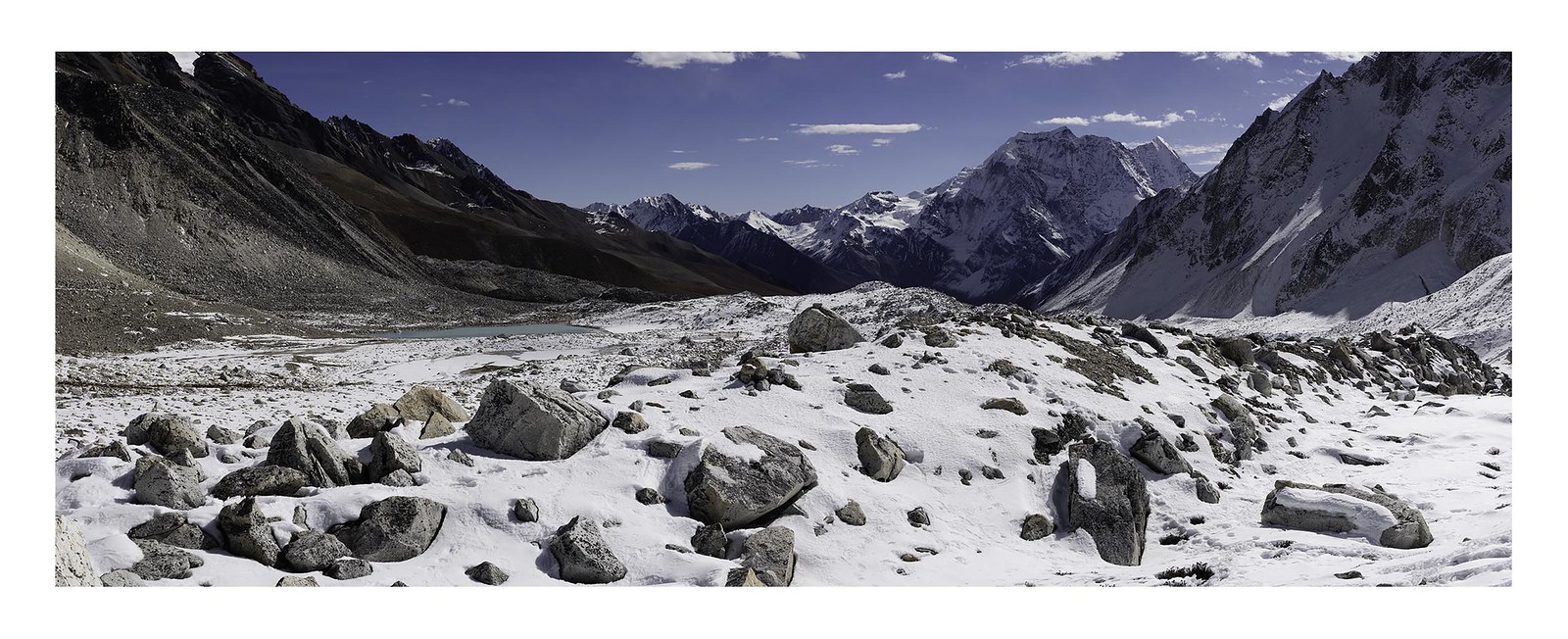
Day 7: The Most Important Day — Acclimatization in Samagaon
This day is not optional. Spending two nights at Samagaon before continuing to higher elevations is a fundamental acclimatization requirement. The classic day hike goes up to Pungyen Glacier and Gompa at approximately 4,800m, following the "climb high, sleep low" principle.
Start early, take it slow, and pay attention to your body. Common altitude symptoms at this elevation include a mild headache, reduced appetite, and broken sleep. These are normal if mild. Confusion, loss of coordination, or a headache that does not respond to ibuprofen and rest are signals to descend immediately.
Days 8–9: Approaching the Pass
Samagaon to Samdo (Day 8) is a short, easy walk through open alpine terrain. Samdo at 3,860m is a Tibetan-influenced village near the Chinese border. There is sometimes border police activity in this area — stay on the marked trail.
Samdo to Dharamsala (Day 9) climbs steadily to 4,460m. Dharamsala is basic — think cold, simple shelter — but it is the last stop before the pass. Eat a proper meal in the late afternoon, set your alarm for 2:30am, and rest.
Day 10: Larke La — The Heart of the Trek
Leave Dharamsala between 2:30am and 4:00am. The early start is essential. By late morning, wind and snowfall typically make conditions on the 5,160m pass dangerous. The pre-dawn crossing is cold and dark but calm.
The summit of Larke La is marked by prayer flags and stone cairns. The panoramic view encompasses Manaslu, Himlung Himal (7,126m), Cheo Himal (6,820m), and Annapurna II (7,937m). On a clear day, it is one of the finest high-altitude panoramas in the Himalayas.
The descent to Bimtang at 3,590m is long and requires concentration. Trekking poles significantly reduce knee impact on this section.
Days 11–12: The Descent to Civilization
Bimtang to Tilche (Day 11) descends 1,290m through rhododendron forests that bloom spectacularly in April and May. Tilche at 2,300m feels warm after the high camp.
Tilche to Dharapani (Day 12) is a short, easy final walking day. You exit the restricted Manaslu Conservation Area at Dharapani, where your permits are inspected one final time.
Day 13: Drive Back to Kathmandu
The return drive from Dharapani follows the Marsyangdi River valley. The road is better than the road to Soti Khola. Most buses arrive in Kathmandu by late afternoon or early evening.
Why 14 Days Works
The 14-day plan works because it respects the mountain's schedule rather than imposing a human one. Each stage ends at a reasonable hour. You never arrive at your tea house after dark. The acclimatization is built in properly. And you carry a weather buffer — if the pass is closed on Day 10, you wait at Dharamsala and cross on Day 11, completing the circuit a day later without any scrambling.
This is the itinerary worth planning for.